Prediction of Shoreline Changes using Digital Shoreline Analysis System (DSAS) in Likas Bay, Sabah
Keywords:
Shoreline change rate, DSAS, shoreline prediction, Likas BayAbstract
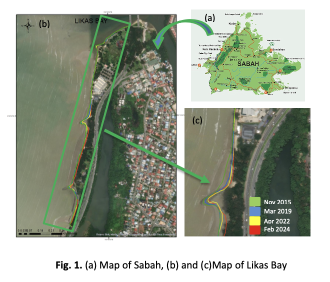
Shoreline changes are dynamic processes influenced by natural forces and human activities. Natural factors, including wave action, tidal currents, sediment supply, and geological processes play a crucial role in shaping coastal morphology and determining the rate of shoreline change. Shoreline retreat (erosion) can have detrimental effects, including habitat loss, infrastructure damage, and increased vulnerability to coastal hazards. Likas Bay, located along the Tanjung Lipat coastline of Kota Kinabalu, Sabah, has undergone significant shoreline changes in recent decades due to coastal development, reclamation projects, and hydrodynamic forces. This study assesses and predicts shoreline change rates from 2015 to 2024 using the Digital Shoreline Analysis System (DSAS). Using satellite imagery data, the shoreline positions were digitized and analyzed to compute rates of change, including End Point Rate (EPR) and Linear Regression Rate (LRR). Based on these rates, projections were generated for the next 10 and 20 years (2034 and 2044). The results revealed that the maximum and minimum EPR values are -2.57 and 0.08, and the minimum and maximum LRR values are -2.94 and 0.11, respectively. The prediction of shoreline change rates in Teluk Likas for the next 10 and 20 years indicates that the affected areas are 2.4 ha and 4.21 ha, respectively. The findings provide valuable insights for coastal management and sustainable development in Likas Bay. Predictive modeling indicates that continuous erosion will occur in specific hotspots unless mitigation measures are implemented. These findings provide valuable insights for coastal management and mitigation strategies, emphasizing the need for sustainable development and conservation efforts in Likas Bay and offering valuable insights for coastal management and policy planning in Sabah.