Assessing the Impact of an Earthquake on Water Quality Parameters: A Hybrid Satellite-Based and Ground Evaluation of Environmental Quality and Stability
Keywords:
Water quality impact, earthquake, integrated satellite-based and ground evaluationAbstract
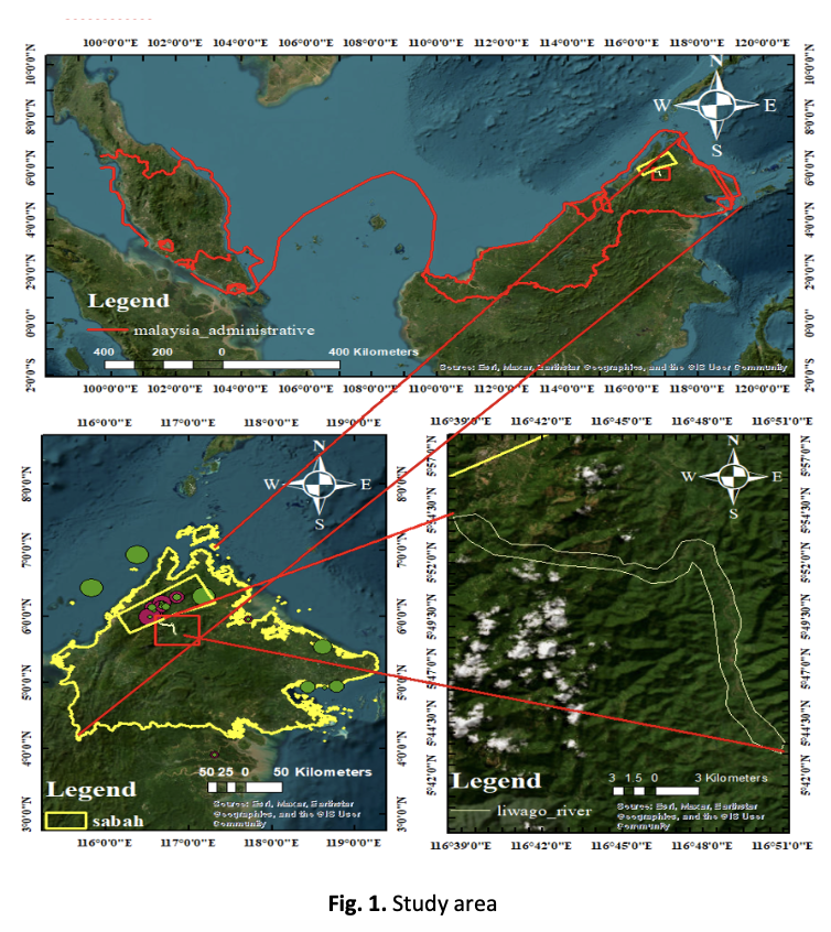
The immediate changes in water quality can have various causes and origins, depending on the sources of pollution, water quality can change. Monitoring surface water pollution is crucial for maintaining the natural environment and human health. Malaysia is not prone to earthquakes, but it is highly susceptible to various geological and geomorphological factors associated with hydrometeorological hazards. The most recent significant earthquake in Malaysia occurred in 2015 in Ranau, Sabah, with a magnitude of 6.0 on June 5th, lasting for 30 seconds and impacting the quality of surface water. Environmental hazards, such as earthquakes, can contribute to changes in water quality. This study aims to identify the key water quality parameters affected by the earthquake in Sabah, Malaysia. Data was collected before and after the earthquake, using both ground-based and satellite-based methods. Satellite data from Landsat 8, including Soil Adjusted Vegetation Index (SAVI), Normalized Difference Vegetation Index (NDVI), and Normalized Difference Water Index (NDWI), were analyzed before and after the earthquake. The Kruskal-Wallis test was used to determine significant water quality parameters impacted by the earthquake, focusing on physical and chemical parameters such as turbidity, color, pH, electrical conductivity (EC), total dissolved solids (TDS), dissolved oxygen (DO), nitrates (NO₃), iron (Fe), manganese (Mn), aluminum (Al), alkalinity, hardness, chloride (Cl), and sulfate (SO₄²⁻) for the years 2014 and 2015. This nonparametric method enables the comparison of multiple independent samples without the need to assume normality. Ground data did not provide a clear understanding of how changes in the surface of the river and its surroundings affect the surface ground. The integration of satellite and ground data showed that alterations in river surface features, such as vegetation, soil, and water availability, had a significant impact on water quality parameters.